An example of the taking of land and penning in of communities can be found in the village of Far'un. The apartheid wall was a first step. As can be seen in the accompanying map at places the apartheid wall is placed 3 km inside the green line (1949 armistice line). A friend of ours had 400 acres confiscated when they built the wall.
Then the Israeli occupiers wanted check points so they could examine people and vehicles as they crossed from Palestine into Israel. The checkpoints are often elaborate with large buildings and extensive parking areas, all of which are carved out of Palestinian land. In the case of Far'un the occupiers were not satisfied with one check point, the wanted one that only processed trucks (At Tayba), one that only processed Palestinians (Ephraim), and one that only processed Israelis (Kafrait). See these on attached map
The names of the check points dominate the map At Tayba, Ephraim, Kafriat, the location is marked with an X in a circle. The bold red line is the apatheid wall. The dashed green line is the "green line." About centered is the Village of Far'un, it is shown in a yellowish, brownish color. The blue area is all Area C (contoled by Israel)
The apartheid wall around Far'un is mostly a fence, but it is an electified fence that has a road and also a buffer zone on both sides so it is about 50 meters wide of cleared and bulldozed land, Palestinain land. If you look at the attached google image you can see that the apartheid wall is the most prominent feature visible and that it is 2 to 3 times wider than the biggest road in the image. Looking at the map you can see they put the wall right next to the village on the south and west sides, which necessitated demolishing houses. Some people say “Israel wants the most geography with the least demography.” In other words they want the most land they can get without getting any Palestinians. What ever the rational one can see the wall cuts right next to the edge of the village, it separates the villagers from the land they own and which has fed their families for generations.

Besides building the apartheid wall they control the land near the wall. For example in the google image on the left side you can see a brown rectangle. This was the village children's soccer field. But the occupiers decided it was too close to the wall they had just built so they stopped the children from using it under threat that they would be shot. In fact a 9 year old girl was shot (2006) on the road near the ball field, shot just for being there. Adding insult to injury some occupying soldiers drove their jeeps into the ball field spinning their tires and turning tight corners rutting up the ball field. In the village some say the soldiers were drunk. It is hard to imagine how some kids playing ball could be a threat. It is 100 meters to the area of the apartheid wall which is 50 meters wide and another 150 meters to the closest Israeli structure which is a fortified military base. Can the soldiers really be afraid of a child playing socker 300 meters away?
Houses and structures near the apartheid wall have been demolished and continue to be demolished. As an example a family with 4 sons and one daughter worked for 11 years to build a house for the family, but when it was completed the occupiers demolished it (in 2014). Not only did it put 7 people out of a home but the shock and grief caused the father to die. The houses on both sides of this house were not demolished even though they were closer to the wall. There is not some map or a way the residents can tell if their house will be allowed. They build on their land after years of planning, saving and work. When the house is finished they are told it will be demolished. We do not know how many houses have been demolished, but we visited many that were rubble. There are about 12 in the village that are currently scheduled for demolition.
It all seems so irrational. In a large section of land on the southwest of the village (lower right of google image) no farming or activity of any kind is allowed, yet right close to the wall surrounded by this no use area a greenhouse and small field next to it is allowed (see photo).
 |
| These green houses are allowed. The apartheid wall can be seen in the upper left. All the land behind the green house, to the right of the green house and in front is not allowed to be used even to pick olives. |
At another spot a new farm has been scheduled to be demolished including the little new fuit trees.
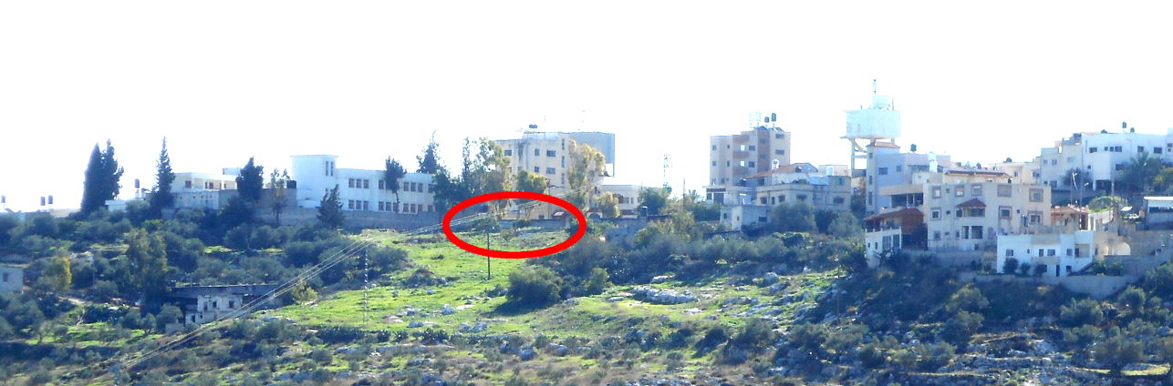
On the north and east side of the village there is no apartheid wall, but here it is Area C, over which the occupiers claim complete control even though they acknowledge they do not own the land or the buildings. On the north side of the village a Christian neighborhood was demolished. You can see from the photo that there are houses, which are not schedued for demolition, on three sides of the demolished neighborhood. One half of the girl's school, also on the north of the village, is scheduled for demolition. In the photo below you can see that it is a continuous wall but that part of it is older. The old part is scheduled to be demolished. Another photo shows a pinkish brown 3 story new building scheduled for demolition yet the buildings around it are not scheduled for demolition.
 |
| The Christian houses were in the area of the red circle. The girls school is to the left of the red circle. |
The left part of school is scheduled for demolition, the right part is not.
On the east of the village the same thing is happening, see the photos of three houses that are scheduled for demolition. They are no where near the apartheid wall, they seem to pose not imaginable threat to anything. These are just new family houses being built as anyone would on the family land after years of planning, work, and pride.
We visited another category of buildings which are not scheduled to be demolished but only because the owners have agreed to stop construction, or repair, and to not use them. These do not appear as part of the numbers of demolitions, but still the work, investment and hope has been stolen from the family.
We visited a building which used to be home, but the family was told they had to move out or it would be demolished (2006). In 2010 Israel gave them permission to convert it from a home to a wedding hall and as such it would not be demolished or at least not now. This building is in the village and surrounded by other buildings which are not under orders to be demolished.
The Village of Far'un is just one example, there is nothing saying this village is to be eliminated yet is subjected to continued demolitions and denial of use of their land on all four sides.